

There are more than 1, 15,435 kilometres of national roads in India. As a result of increasing traffic on the road. The government set an ambitious goal of building 15,000 kilometres of roads in 2016-17, but only 8,200 kilometres were completed owing to conventional construction and monitoring procedures. Drones may be used to monitor construction, speed up the process, and ensure openness, according to India’s Prime Minister. Geospatial solutions enable more effective construction and maintenance of infrastructure projects, such as roads and bridges, by allowing road construction monitoring using drones. Because successful inspection has a direct impact on the transportation network and public safety, early detection of fundamental flaws is critical. The Invent Grids platform provides an advanced tool for monitoring roads and bridges. Highway Corridor Mapping facilitates the discovery of road defects such as potholes and cracks, as well as the alignment of dividers, over line structures, boundaries, and electric lines for street lights, road expansion, and power line crossings.
Road Inspection
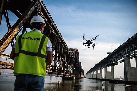
Bridge Inspection
Contractors and inspectors may receive an all-around, in-depth look at the health of bridges and concrete infrastructure by combining drone data with corrosion evaluation. It also keeps employees out of harm’s way, saves money, and, most significantly, assists our state engineers and contractors in doing a crucial task: repairing and rebuilding old infrastructure across the country. Our Drone are a great way for monitoring purposes to predict the structural and functional performance of a complex bridge. The use of robotics in the inspection of various framework evaluations, such as bridges and towers, has evolved. Our Drones’ miniature design is used to capture aerial pictures of, say, a bridge to detect any type of small or severe deterioration, such as little cracks or corrosion, that are difficult to spot from a distance. Some of the advantages of bridge inspection include: When compared to traditional methods, it takes less time to complete a complete inspection task, reduces life risks, and thus ensures public and inspection crew safety. It also obtains more accurate data based on provided safety standards and requirements, and data can be analysed in real-time and saved for later use.
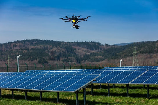
Not just for the PV system itself, but also for surrounding infrastructure like utility lines, substations, and fences, valuable use cases have been proved spanning pre-construction, commissioning, and operations & maintenance. Our Drones’ primary goal is to locate broken solar panels so that they may be repaired by the manufacturer while still under warranty, optimise production, and handle concerns quickly to reduce maintenance costs. For more accurate and thorough examinations, we provide thermal imaging and aerial inspections. Autonomous industries key software’s objective is to identify the faulty Solar Panels so they can be replaced by the manufacturers while they are in warranty, maximize output/efficiency and proactively addressing issues thus minimizing maintenance cost. We leverage drone Thermal Imaging and Aerial Inspections to provide accurate and detailed inspections quicker and more cost effectively. Value of Drones for Solar Farm Inspection are Rapid and Easy scans for Roof tops and arrays, Hot spot identification showing defective cells / Geotagged image, Diagnostic purpose / planning of Panel placement, Infrared signatures show defective panels, Keep the solar farm running at peak efficiency, save time with pre-selected way point aerial inspections.
Solar Plant Inspection
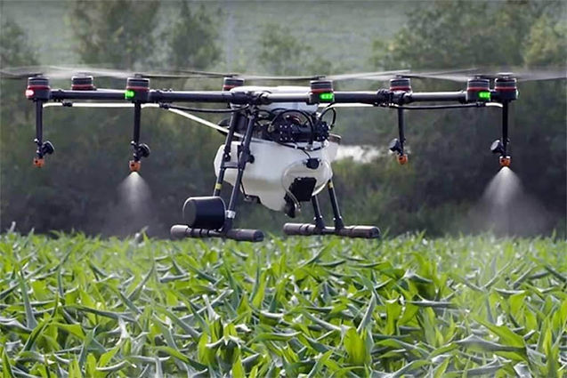
Agriculture Drone Service

We can assist farmers in optimising the use of inputs (seed, fertilisers, and water), responding more rapidly to threats (weeds, pests, and fungus), and crop scouting (validating treatment/actions performed) to save time. Our autonomous agri drone can help you optimise variable-rate prescriptions in real time and predict field yield. And NDVI is a popular metric in agriculture remote sensing, measuring how much more near-infrared light is reflected than visible red. It aids in distinguishing bare soil from grass or woodland, detecting stressed plants, and distinguishing between crops and crop stages

Power line Monitoring
Drones make it possible to acquire the necessary data in advance of identifying and reducing power distribution hazards. Autonomous is providing advanced automated inspections, you can save 30 to 50 percent on expenses and time when utilising drones to examine electricity lines., It also lets the power component to concentrate on fault construction and maintenance planning. Drones’ solution provides for faster and more precise visual data collecting, allowing power companies to focus on problem detection, effective repair, and strategic development and maintenance planning., thus reducing the dangers to surveying crews Drones for inspection of power lines, civil infrastructure, and other items provide benefits such as a quick overview and assessment of the condition, sharp and detailed photographs of defects, high-quality images and video, preventive maintenance planning and optimised production, access to difficult-to-reach areas, reduced downtime, and a high level of personnel safety.
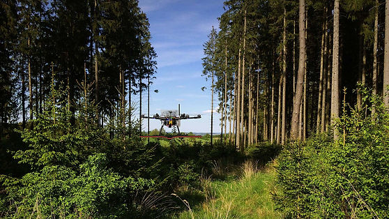
Forest & Wildlife Survey
Autonomous has the potential to transform forest and animal conservation studies to automated modes without risking any preserved things/damaging the nature . Drones give a bird’s-eye perspective of forests and animals, as well as information, pictures, and data that would otherwise be difficult or prohibitively expensive to get. Drones are not only a safer, more cost-effective, and more exact way for conversationalists to watch and study individuals, but they are also frequently less expensive, more efficient, and more precise than traditional methods.
Our drones can help track unlawful operations, monitor animals, and calculate their number, plan reforestation, Wildlife Habitat Mapping, Real-Time Monitoring of Active Fires, and poaching activities, among other things. Monitoring, appraisal of increasing stock, biomass, and increase in forest cover on a regular basis. By monitoring forest health, encroachments, tree-felling, forest fires, poaching, the state of water bodies, biodiversity preservation, and mangrove conservation, drones for forest and wildlife help us build a better tomorrow. Drone technology is increasingly being used in the forest for the creation of working plans, surveys, demarcation, and forest resource assessments. Drones equipped with high-resolution cameras may collect precise images as well as geographical metadata.